|
|
Guadalupe River

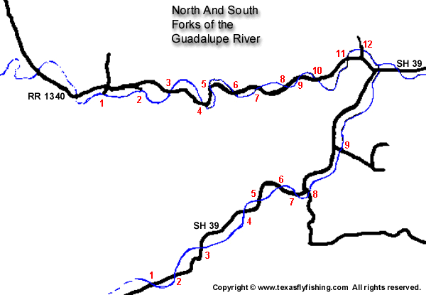
View large map of North and South forks of Guadalupe River
|
South Fork Guadalupe
The first three areas of interest on the South Fork Guadalupe are owned by Lynxhaven Lodge, 11.5 miles west of Hunt, Texas. The rate for fishing the river within ranch boundaries is $15 per day. If you are like me, traveling from out of town for the weekend, this is the best way to fish the Guadalupe. First of all, many parts of the Guadalupe river are private. Rather than looking over your shoulder all day for angry landowners, you can concentrate on the fish. The $15 also gets you 3 miles of fishable water, and trust me, the fishing is good. Finally, the scenery in this area beats any other location on the Guadalupe. This area is further from any town on the Guadalupe than at any other accessible location. There are no houses to break up the tranquility of the river and the water is clean and clear.
1. This is the southernmost fishable access point of the Lynxhaven Ranch, or the South Fork Guadalupe for that matter. Parking
is available for one vehicle. Upstream, the water is generally too shallow to fish until you reach the dam. Fish the
edges of the river and concentrate on the deep water on the south side of the dam. Wading downstream is possible for
about fifty yards, at which point the water becomes too deep. This would be a nice area for a float tube. However,
floating to the next point is not possible without a long portage.
2. To be explored.
3. To be explored.
4. This low water crossing is the first unposted access on the river. The water runs shallow and holds good numbers of
medium sized sunfish and some small bass.
5. Access is good to this crossing below the River Inn Resort. It is possible to wade to point 6 downstream if the
water is low. There are some large but wary bass between these two access points.
6. The river crosses SH 39 here just south of Felix Fisher road. One could park here and wade upstream to point 5, and
then walk back to the car on SH 39. There are some pretty nice spots in between.
7. The river is posted on the downstream side of this crossing near Camp Mystic, permission could possibly be obtained
from camp officials. Fishing is poor below the dam on the upstream side. Above the dam is a private area that would be
risky to fish.
8. A little road shoots off of SH 34 here. The 20 or so posted signs do more damage to the aesthetics of the area near
the crossing than trespassers ever could.
9. This crossing is at the entrance to Broken Arrow YMCA camp. The best parking in the area is across SH 39
at Mountain Sports. One would need to walk at least 150 yards up or
downstream to find the best fishing.
North Fork Guadalupe
1. Just across from the check in station of the Kerr Wildlife Management Area is a short gravel path that leads to the river. Several springs form the beginning of the north fork of the Guadalupe here. Although this is a really pretty spot, there are not many fish to be found. Walk downstream to the deeper pools for some small perch and warmouth.
2. Another gravel road leaves RR 1340 about 1/2 mile from the Kerr Wildlife Management Area. The river bottom here is wide with deceptively deep channels. Wading is good up and downstream. Felt bottomed wading boots are recommended due to the slipperiness of the rocks. The fish in this area are incredibly spooky. The expansive view of the canyon walls is quite impressive.
3. A bridge crosses high above the river here. To fish this area would require permission from the landowners due to the limited access afforded by the bridge. The Wagon Wheel restaurant is just west of here and comes highly recommended.
4. This is a low water crossing about 8.5 miles from Hunt. The river is wide and shallow upstream with very little vegetation or cover. The downstream side is a bit deeper. Use the scattered boulders for cover and make long casts to the skittish fish along the banks.
5. The river is dammed upstream of this low water crossing and would require trespass to fish. The downstream side is shallow, wide, and clear; not to mention unposted. Some small bass and sunfish hang around the crossing. Larger fish can be found in the deep holes downstream.
6. This area is fenced upstream. The downstream side is nice for 100 yards or so until the river becomes too deep to wade. I like to wade as far downstream as my waders permit and then cast a wooly bugger near the bank in the deeper water.
7. Bear Creek runs into the Guadalupe here at Stumberg Ranch. The water is deep upstream and dammed below.
8. There is a house on the upstream side of this low water crossing. While the river is fishable here, it would probably be rude to use this part of the river. The downstream side is also unposted but looks to be private.
9. This is a pretty spot about 4 miles from Hunt, Texas. There are some fish hanging around the crossing but the bank is posted up and downstream.
10. The river is posted downstream here. The downstream side is wide and holds vegetation, but not recommended.
11. This area is not posted and parking is good. The current is fast downstream and branches hang low on each side. The pool upstream is pretty, but cars race by and the fish are spooky. The river is fast and narrow above the pool and the possibility of trespassing is high. A interesting replica of Stonehenge and some Easter Island Monoliths lie just up the road to the west.
12. River road turns off of RR 1340 about 1/2 mile west of Kerrville. The upstream side of the river is posted. A float tube would be required to get at the large bass and sunfish on the downstream side. The water is clear and the area is pretty.
|
Guadalupe River above Canyon Lake Dam
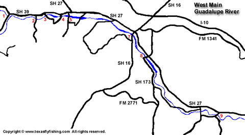
View large map of western portion of the main Guadalupe River
|
1. The river crosses SH 39 just east of Hunt at two different points here. Note that the crossing closest to Hunt is part of the North Fork Guadalupe described above. Wading here would be difficult due to the water depth, trees, and local swimmers and bait fishermen. Though generally disregarded, the upstream side of the bridge is posted.
2. This is the entrance to Waltonia Lodges. The river on the upstream side of the crossing is dammed and reaches a depth of 30 feet. Several bass in the 9 lb. class have been caught (and released) in the river above the dam. Thornton Secor, the owner of Waltonia Lodges, mentioned an older gentleman who once proclaimed this area to be some of the finest fly-fishing he had ever experienced throughout his broad fly fishing travels. Could this have been the late, great Bud Priddy?
I have yet to explore the downstream side of this crossing, but there are some cascading falls that may lead to some nice pools.
Contact Thornton at (830)367-5713 for information on lodging and fishing in this area.
3. Looker Road crosses the river here just West of New Lake Ingram. Parking is not allowed within 500 feet of the bridge, and the land along the river is private and somewhat residential. A quick drop off of a float tube would be an ideal solution. A short wade downstream leads to an excellent pool inhabited by larger than average size bass and sunfish. A float upstream leads to more of the same, though in a less scenic setting.
4. This area is reached by exiting Old Ingram Loop from SH 39. Turn south on Indian Creek Road and proceed to the bridge. Parking is available on the south side of the river. Floatation would be required on the west side of the bridge. Wading downstream covers some good sunfish pools and deep water eventually.
5. This crossing is reached by exiting Arcadia Loop from SH 39. Turn south on Bear Creek Road and park on the far side of the bridge. The downstream side is wide and shallow, but eventually gets deep enough to hold some good fish.
6. Getting to this point is a bit tricky, but worth the effort. Exit south on FM 480 from US 27, this will take you to Center Point. Turn right to Lions Park. Once in Lions Park, proceed past the dam. Just after the dam, take River Road to the west. Continue down River Road until you reach the crossing. Park at the crossing and wade downstream about 100 yards to the confluence of Turtle Creek. This area is isolated, quiet, and full of nice bass and sunfish.
7. Lion's Park in Center Point, though I have yet to try it, might be a good launch point for a float to the FM 1350 crossing downstream. The best method for a launch would entail driving down the dirt path on the north side of the river until the water smoothes out. Launch your canoe here and then leave your car in the parking area of the park.
8. The crossing at FM 1350 offers easy access, though at times the water is just a little too deep to wade. Stick close to the banks and wade downstream for the best fishing opportunities.
9. Roane Road exits from SH 27 a couple miles east of Center Point, Tx. Access to this area is very good and parking for two vehicles is available on the south side of the low bridge. The river runs atop pure bedrock at this crossing and the next; this means fast water and slick wading. Felt bottom wading boots are a real asset. The small sunfish and occasional bass will crowd into any slow water that is available. The best strategy is to fish upstream and let the fly drift naturally past these ambush points.
|

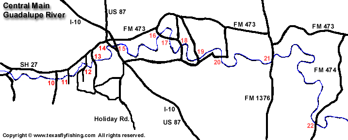
View large map of central portion of the main Guadalupe River
|
10. Lane Valley Road crosses the river here, just south of SH 27. Access and parking are good here, and the structure of the river is similar to the previous point.
11. This is the low bridge on Biermann Lane. Locals occasionally use this area for camping. Wading is good here once past the deep water near the bridge. The riverbed is rocky upstream and somewhat sandy downstream. I consider this a "big" area, with enough fish and wadable river for an entire day of fishing.
12. Hermann Sonns Road crosses the river here. Locals use the deep water near the bridge for swimming, but there are some shallow areas downstream and nice pools that hold plenty of meaty sunfish.
13. This area is known as Mill Road dam. Turn south from SH 27 onto Pankrate Road, and then right on to Mill Dam Road. The area is heavily used by locals during the summer. Park at the top of the hill on the north side of the bridge using the abandon road. There is good wading both up and downstream, and walking the banks in the bridge area would probably be permissible.
14. US 87 crosses high above the river here, just west of I-10. Access is not possible at this point, but I ritually stop at the Double D Diner (just north of the bridge) for a good greasy breakfast before a hard days fishing.
15. The Guadlupe runs beneath I-10 here, just southeast of Comfort, Tx. Exit the highway on the southeast side and drive down the dirt road. Proceeding straight down the dirt road, the river crosses under the I-10 bridge. The water under the bridge is deep and the current is too fast for fishing from float tubes or canoes.
The best alternative is to turn left about 1/2 the way down the dirt road. The river in this area is not as deep as it is under the bridge and allows some wading further away from the noise of I-10.
Overall, this portion of the river is heavily used, and therefore trashed up by those who seek convenient access to the river. That, and the roar from the bridge makes this area one to avoid.
16. This is a low water crossing on South River Bend Road, which turns south off of FM 473 east of Comfort, Tx. Parking on the road is not permitted, but a four-wheel drive vehicle can easily park on the dry creek bed next to the river. This is a peaceful spot and the water is nice and clear.
The easiest wading is on the downstream side. Look for boulders and cast nymphs into their wake for small bass and average sized sunfish.
Chest waders are useful when exploring upstream. This side holds deeper water and larger fish but would be best navigated in a kayak due to the swift current.
17. This is the second low water crossing on the aforementioned South River Bend Road. There is enough parking off of the road for one or two cars on the south side of the river.
Some wading near the bridge is possible, but for the most part, floatation would be required. Again, a kayak would be recommended due to the swiftness of the current. This would be a short float to the next crossing downstream.
There are some nice bass and sunfish on both sides of the crossing, as well as a couple of really nice carp if you are patient.
18. The third low water crossing on South River Bend Road is the closest to Waring, Tx., which lies to the southeast. Parking is difficult on the road, but is best on the south side of the river. In most cases, the river runs DANGEROUSLY fast over the crossing. There is a pothole in the middle of the crossing that could cause a car to be carried downstream. I strongly recommend not crossing this portion of the river, even in a truck. The best method of reaching this point would be to exit South River Bend Road from FM 1621 and park on the south side of the river.
While wading in this area is limited to standing on the bridge, this is a really nice place to put in for a float to the next crossing west of Waring. Healthy bass and sunfish abound on the downstream side.
19. To reach this crossing, head east from Waring approximately 1/4 mile on Waring-Welfare Road. Turn north on Zoeller Road and drive about 100 yards to the north side of the river and park on the west side of the road (parking on the east side would block the farmer's access to their land via lay-down gate.)
Wading downstream is tricky but rewarding for about 300 yards, at which point the water gets too deep.
When wading upstream, pay particular attention not to trespass onto the banks of the river. This area is popular for float tubes and the landowners would be rightfully perturbed by folks wandering about their property.
This is a good launch point for all methods of floatation to the next crossing.
20. Just over a mile from point 19, this low water crossing offers good parking, no posted signs, and easy access to the river.
The water above the crossing is slow, wide, and generally knee-deep. This is a great place for beginning fly casters to work on their technique. Good quantities of bass and sunfish lurk among the roots near the riverbank.
The downstream side of the crossing runs quick and narrow. A long wade downstream will bring you to the delta of Big Joshua Creek, which offers fine fishing. One could also float to the next point from here.
21. FM 1376 crosses here at the confluence of the Guadalupe and Sister Creek. Some wading is available, but floatation would be required any distance from the noisy bridge.
22. FM 474 crosses the Guadlupe here at Harkins Crossing. One could drive a 4X4 down the rough dirt path to the riverbank, but should avoid passing through the gate on the right hand side. From here to Canyon Lake, the river moves much more water than at previous crossings and is better suited for floating. Some wading is possible upstream, but wading to fishable water is tough.
|
Guadalupe River above Canyon Lake Dam

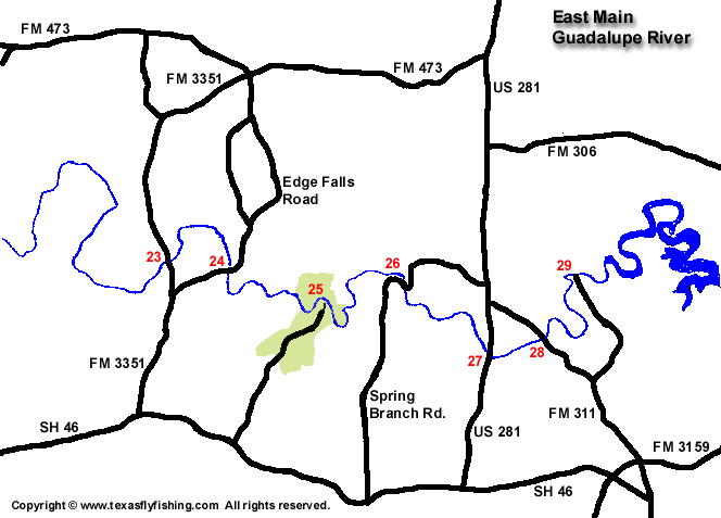
View large map of eastern portion of the main Guadalupe River
|
23. FM 3351 crosses high above the river here. Just north of the crossing is Bergheim Campground, which is the only legal access to this portion of the river. The local game warden has recently issued several citations to those who try to enter at the bridge. Good wading is available up and downstream, though the area is crowded with swimmers when the weather gets warm.
Bergheim Campground offers shuttle service for $15 to Edge Falls road, $20 to Guadalupe State Park, and $25 to points further downstream. Kayaks and canoes can be rented for $20 with shuttle to Edge Falls Road. All of these floats will cover good fishing for large bass and sunfish. Call 830-336-2235 to plan in advance.
24. A low bridge on Edge Falls Road offers easy access at this point, but there is only convenient parking for one vehicle. Wading is difficult due to the deep fast moving current here. This is a good pickup for a quick float from the Bergheim Campground.
25. Off of SH 46, Guadalupe State Park boasts 4 miles of river frontage. While the park is crowded when the weather warms up, a hike to the more remote areas will put you into some good fishing areas. The park occasionally prohibits wading in the heat of the summer due to bacteria alerts, so call ahead of time at 830-438-2656.
26. Spring Branch Road crosses high above the river here west of US 281. Just north of the bridge, turn east on old spring branch road, and follow it to the river.
Wading is difficult in this portion of the river, but the wide sandy bank allows for easy casting. Good black and smallmouth bass as well as the occasional striper and white bass are available along this stretch of the river.
27. Guadlupe Canoe Livery provides canoe rental and shuttle service here at the US 281 crossing. Access to the area is by floatation only. Floating into the various creeks that enter the river here provide some good opportunities at large fish.
28. This is the crossing at FM 311. Access is difficult due to the high bridge. However, wade fishing is good if you are willing to scramble down the concrete ditch beside the bridge. The best fishing is in the deeper water downstream.
29. This is a low bridge at Rebecca Creek Crossing. Access is easy and the area is often used by locals. One should dock well above the bridge if floating to this point due to the dangerous current beneath the bridge.
This is a good area for smallmouth and white bass in the spring.
|
Guadalupe River below Canyon Lake
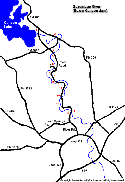
View large map of the Guadalupe River below Canyon Lake Dam
|
1. The tailwaters of Canyon Dam begin at this deep pool at the north end of River Road off of FM 306. A steep stairway, leads down from the parking area. While a float tube wouldn't be difficult to carry down the steps, a canoe might be a problem. The north side of the pool is generally crowded with fisherman, but the south side is more fly fisherman friendly and usually available. Wading is somewhat difficult if the release rate is over 300 cfs. Stick to the south bank when wading to avoid trespass.
While not the most scenic area of the river, the pool does contain stripers that will put a nice bend in a fly rod. Texas Parks and Wildlife stocks this area with 6" to 12" trout. Being a poor commercial launch site, this area is somewhat immune to the "rubber hatch" (float tubers). The stocked trout seem to hang on further into the year since the water in this area is generally colder than the rest of the river.
2. FM 306 passes high above the Guadalupe at this point. Access is not possible to the public. However, Maricopa Ranch resort lies just west of the bridge, and access is available to guests.
The river is deep in this area and floatation would be advisable if not necessary. Call (830)964-3600 ahead of time for information on shuttle availability. They are quite flexible on pickup times and locations.
3. FM 306 crosses the river again approximately 1 mile from point 2 above. Whitewater Sports Campground allows access to the river for a fee. There are several hundred yards of good wading downstream.
Whitewater also provide shuttle service to Rocky Beach or Guadalupe Landing throughout the year for about $10 per boat.
4. Rio Raft provides excellent access to the river just above the 4th crossing. Both Texas Parks and Wildlife and Guadalupe River Trout Unlimited stock this area with rainbow and brown trout. Access is free to GRTU permit holders, $5 otherwise.
Wading is possible for a short distance past the bridge and far upstream. Since the north side of the river tends to be the deepest, one should cross to the south side of the river just upstream of the bridge, and then proceed wading up or downstream.
Rio Raft will shuttle you to points 2 or 3, and retrieve all floatation just above the 4th crossing.
5. This is the 4th crossing of river road. Jak's lies on the south side of the bridge, but is not open during the winter.
6. The Little Ponderosa bridge crosses high above the river, just north of River Road. The parking area on the south side of the river is leased by GRTU during the winter.
Good wading is available both up and downstream by either floating from one of the points above or lease access.
7. Lazy L&L Campgrounds owns more than 1 mile of riverfront property from just below point 6 above. This area is available only to GRTU lease members or via floatation from above. Wading is somewhat difficult in most areas.
8. This area is known as Rocky Beach and is used as a pickup or launch site by several of the shuttle services.
9. Camp Bean's lies just north of the 3rd crossing. Both Texas Parks and Wildlife and Guadalupe River Trout Unlimited stock this area with rainbow and brown trout. Access is available for $6 to the public and free to GRTU lease members. Park anywhere on the road and an attendant will be along to collect parking fees.
Though generally crowded, some of the best fishing is in the deep water downstream of the bridge.
10. This is the 3rd crossing of river road. The riverbank below the bridge is available only to GRTU lease members. A dirt road runs along the river for 1/2 mile or so, depending on how many trees have been removed since the flood.
11. Guadalupe Landing is also used as a pickup site by several shuttle services, including Whitewater Sports. Good wading is available upstream for larger than average trout on nymphs fished deep. This area is a leased by GRTU during the winter.
12. This is the 2nd Crossing of river road.
13. River Bend Camp
14. First Crossing
15. Hueco Springs Campsite
|
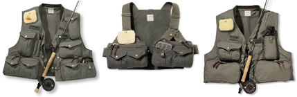
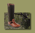
Filson Flyfishing Vests from Solomon Outfitters
|
About Texas Flyfishing |
Texas Flyfishing Home |
Fly fishing the Rivers |
The Fish |
Texas Flyfishing Trip Planner |
Texas Fly fishing Outfitters |
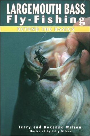
Texas Flyfishing Book Store |
Texas Fly-fishing Photos |
Texas Fly-fishing Equipment |
Texas Fly fishing Links |
Contact Texas Flyfishing
|
|
|
 TEXAS FLYFISHING